Difference between revisions of "Local Government Area (LGA)"
(Add 'About Geocaching Australia LGA Data' & 'Howto: My LGA') |
|||
| Line 11: | Line 11: | ||
==LGAs and Geocaching.== | ==LGAs and Geocaching.== | ||
Local Government Areas (LGAs) can serve as an intriguing backdrop for geocaching adventures, similar to how county challenges are popular among geocachers in the USA. Both provide geographical boundaries that offer an extra layer of challenge and exploration for enthusiasts of the activity. In the USA, county challenges encourage geocachers to find a cache in each county of a state, leading them to explore diverse terrains and regions. Similarly, in Australia, some geocachers set personal goals or challenges to find caches in each LGA within a state or territory. This adds an element of regional exploration, pushing geocachers to venture into different communities and environments that they may not otherwise visit. | Local Government Areas (LGAs) can serve as an intriguing backdrop for geocaching adventures, similar to how county challenges are popular among geocachers in the USA. Both provide geographical boundaries that offer an extra layer of challenge and exploration for enthusiasts of the activity. In the USA, county challenges encourage geocachers to find a cache in each county of a state, leading them to explore diverse terrains and regions. Similarly, in Australia, some geocachers set personal goals or challenges to find caches in each LGA within a state or territory. This adds an element of regional exploration, pushing geocachers to venture into different communities and environments that they may not otherwise visit. | ||
| + | |||
| + | ==About Geocaching Australia LGA Data== | ||
| + | Geocaching Australia only provides LGA's for Australia and New Zealand (Regional Councils). | ||
| + | LGA boundaries are sourced from Open Street Maps (OSM) with areas that are not present in OSM being generated based on other available data. We do not provide any guarantee that the LGA boundaries match the local government areas and are provided for statistical and mapping purposes only. We do not encourage you to use these boundaries for another other purposes. | ||
| + | Geocaching Australia is aware that some boundaries may have gaps between LGA's or overlap other LGA's based on the data sources from OSM. We do not curate the quality of data and accept it 'as is' from the source. Some LGA's are not present in the OSM data as they are Unincorporated Areas and do not have a boundary. Unincorporated areas are often in remote locations, cover vast areas, or have very small populations. Some Unincorporated areas are split into smaller LGA's for mapping purposes and some remain are very large areas with multiple, distinct boundaries. Some offshore islands are incorporated into the LGA boundaries and some of these are not associated with a specific state as they are administered by a level of government other than the state or local government. For example, management of Macquarie Island is the responsibility of the Tasmania Parks and Wildlife Service rather than a local council. | ||
| + | Some shoreline boundaries are set off-shore to cover islands and inlets and some follow the shore-line quite closely. This may result is some LGA's being 'rounded' or 'bumpy' vs. some LGA's which are quite 'crinkly'. The data is provided and used 'as-is' from OSM as Geocaching Australia does not attempt to correct boundary areas. There are also LGA boundaries that are 'disconnected' from others. e.g. French Island in Victoria is a separate LGA with no connecting border to any other LGA. It appears as a true island surrounded by uncorrected water. However, another island such as Rottnest Island in Western Australia is connected to the mainland through the Cockburn LGA. | ||
| + | Geocaching Australia is aware that when attempting to show the LGA's for New Zealand they will sometimes not render correctly and this is due to the data for the bounding box crossing the antimeridian, the line at 180°, opposite the prime meridian. Moving the map or zooming in to New Zealand may address that issue. | ||
| + | |||
| + | ==Howto: My LGA== | ||
| + | You can access the My LGA page from your [https://geocaching.com.au/my/ "My Cacher Space"] which also controls access to all of your cacher space items by clicking on "Local Government Area". You can also access the page directly at [https://geocaching.com.au/my/lga/ https://geocaching.com.au/my/lga/] | ||
| + | |||
| + | Your '''My Query''' is used to generate the base data for furhter refinement in this selection. Simply start typing the name of one of your My Query's and then select the name to use it. | ||
| + | You can use the '''State / Island''' selector to further refine your base data. | ||
| + | This form treats all Found, DNF and Owned geocaches as matching criteria. If you only want Found caches in your results, your My Query should return only those caches that you have found. If you only want DNF caches, then your My Query should return only those caches that you have logged a DNF against. | ||
| + | You may refine your My Query here by selecting '''All Sources''' to use every cache regardless of source listing site as the criteria. If you want to filter down to only '''Geocaching Australia''' caches or '''Groundspeak''' caches, use the appropriate selector. | ||
| + | '''Bounding Box''' and '''Contiguous Zone Path''' are mutually exclusive. We recommend you complete date for one or the other, but not both. | ||
| + | |||
| + | A '''Bounding Box''' is a distance, North, South, East and West from a set of co-ordinates in kilometers. i.e. a Square x kilometers along each side with the co-ordinates in the centre. | ||
| + | |||
| + | A '''Contiguous Zone Path''' will attempt to find a path from one zone to another where every zone in between is connected. Simply start typing the name of the LGA into the Start Zone and Stop Zone boxes to set the start and end zones. | ||
| + | |||
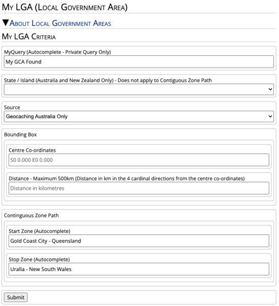
| + | [[File:LGA_Setup1.png|550px|left|thumb|alt=An example of the My LGA form being used to find out if a cacher has found GCA caches in a Contiguous Zone Path between two LGAs|An example of the My LGA form being used to find out if a cacher has found GCA caches in a Contiguous Zone Path between two LGAs]] | ||
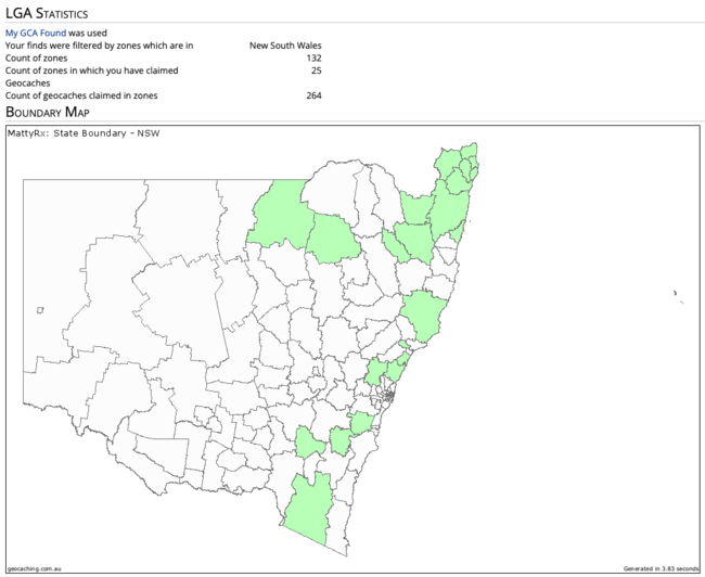
| + | [[File:LGA_Stats1.png|650px|right|thumb|alt=Example output from the My LGA form. This cacher selected a query containing their GCA Finds - and have selected NSW as the State|Example output from the My LGA form. This cacher selected a query containing their GCA Finds - and have selected NSW as the State ]] | ||
Revision as of 08:08, 26 October 2023
Contents
What is an LGA?
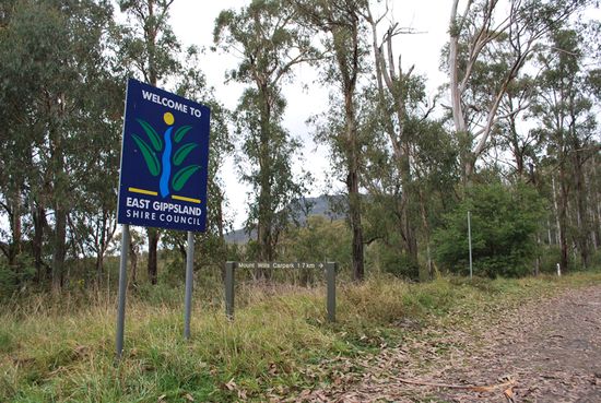
In Australia, a Local Government Area (LGA) is a key unit of local administration, commonly known as a "council." These councils operate within individual states and territories, serving as the third tier of governance after federal and state levels. LGAs have been established to better address the unique needs and concerns of specific regional or community groups. Their responsibilities typically encompass local road maintenance, public recreation facilities, town planning, waste management, and various community services. The size and scope of an LGA can vary widely, ranging from rural shires with smaller populations to major urban centres.
How do I determine an LGA’s boundaries?
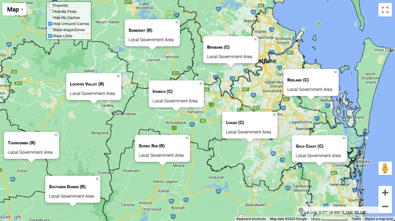
The maps at Geocaching Australiahave the functionality to display LGA boundaries. Simply select the ‘Show LGAs’ box in the map, and boundaries will be drawn on the map. As you zoom in or out – or pan around the map, you’ll see more boundaries being drawn. Clicking on the map will reveal the LGA name of the point selected.
LGAs and Geocaching.
Local Government Areas (LGAs) can serve as an intriguing backdrop for geocaching adventures, similar to how county challenges are popular among geocachers in the USA. Both provide geographical boundaries that offer an extra layer of challenge and exploration for enthusiasts of the activity. In the USA, county challenges encourage geocachers to find a cache in each county of a state, leading them to explore diverse terrains and regions. Similarly, in Australia, some geocachers set personal goals or challenges to find caches in each LGA within a state or territory. This adds an element of regional exploration, pushing geocachers to venture into different communities and environments that they may not otherwise visit.
About Geocaching Australia LGA Data
Geocaching Australia only provides LGA's for Australia and New Zealand (Regional Councils). LGA boundaries are sourced from Open Street Maps (OSM) with areas that are not present in OSM being generated based on other available data. We do not provide any guarantee that the LGA boundaries match the local government areas and are provided for statistical and mapping purposes only. We do not encourage you to use these boundaries for another other purposes. Geocaching Australia is aware that some boundaries may have gaps between LGA's or overlap other LGA's based on the data sources from OSM. We do not curate the quality of data and accept it 'as is' from the source. Some LGA's are not present in the OSM data as they are Unincorporated Areas and do not have a boundary. Unincorporated areas are often in remote locations, cover vast areas, or have very small populations. Some Unincorporated areas are split into smaller LGA's for mapping purposes and some remain are very large areas with multiple, distinct boundaries. Some offshore islands are incorporated into the LGA boundaries and some of these are not associated with a specific state as they are administered by a level of government other than the state or local government. For example, management of Macquarie Island is the responsibility of the Tasmania Parks and Wildlife Service rather than a local council. Some shoreline boundaries are set off-shore to cover islands and inlets and some follow the shore-line quite closely. This may result is some LGA's being 'rounded' or 'bumpy' vs. some LGA's which are quite 'crinkly'. The data is provided and used 'as-is' from OSM as Geocaching Australia does not attempt to correct boundary areas. There are also LGA boundaries that are 'disconnected' from others. e.g. French Island in Victoria is a separate LGA with no connecting border to any other LGA. It appears as a true island surrounded by uncorrected water. However, another island such as Rottnest Island in Western Australia is connected to the mainland through the Cockburn LGA. Geocaching Australia is aware that when attempting to show the LGA's for New Zealand they will sometimes not render correctly and this is due to the data for the bounding box crossing the antimeridian, the line at 180°, opposite the prime meridian. Moving the map or zooming in to New Zealand may address that issue.
Howto: My LGA
You can access the My LGA page from your "My Cacher Space" which also controls access to all of your cacher space items by clicking on "Local Government Area". You can also access the page directly at https://geocaching.com.au/my/lga/
Your My Query is used to generate the base data for furhter refinement in this selection. Simply start typing the name of one of your My Query's and then select the name to use it. You can use the State / Island selector to further refine your base data. This form treats all Found, DNF and Owned geocaches as matching criteria. If you only want Found caches in your results, your My Query should return only those caches that you have found. If you only want DNF caches, then your My Query should return only those caches that you have logged a DNF against. You may refine your My Query here by selecting All Sources to use every cache regardless of source listing site as the criteria. If you want to filter down to only Geocaching Australia caches or Groundspeak caches, use the appropriate selector. Bounding Box and Contiguous Zone Path are mutually exclusive. We recommend you complete date for one or the other, but not both.
A Bounding Box is a distance, North, South, East and West from a set of co-ordinates in kilometers. i.e. a Square x kilometers along each side with the co-ordinates in the centre.
A Contiguous Zone Path will attempt to find a path from one zone to another where every zone in between is connected. Simply start typing the name of the LGA into the Start Zone and Stop Zone boxes to set the start and end zones.


