Setting a Geogaine
From GeoWiki
Contents
Before you start
- The aim of a Geogaine is for a team of players to find 16 caches whilst on foot in a 3 hour time frame.
- The finders record their finds by stamping their control card with a unique stamp found in each cache.
- The 16 caches are in 4 regions of 4 and have a different difficulty rating.
- Very easy and easy terrain should be equivalent to geocaching terrain type 1 or 2.
- Medium terrain should be terrain 2-3 whilst Hard should be roughly 3 to 4.
- The total distance travelled to collect all caches should be less than 18 km.
Locations
- Firstly choose a central location for a Hash House (HH). Make sure you have the HH located in either Very Easy or Easy region.
- Make sure than there are areas suitable for Medium and Hard terrain within 2km.
- Choose an initial cache location for each group.
- The initial location for each region should no be more than 2km from the HH.
- For each region find 3 additional cache locations within the region roughly 1km from the initial region cache.
- For each of the 16 locations record the location coordinates, the hiding location, a suitable clue and difficulty and terrain ratings.
Prepare Data
- Upload the 16 locations and the HH into GSAK and export it into Excel and Mapsource of equivalent program.
Clue sheets
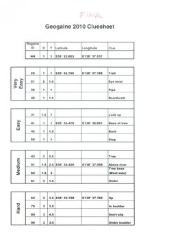
- Using Excel adjust the export from section 2 to have columns for the Geogaine ID, D, T Latitude, longitude and clue.
- Calculate the points value for each Geogaine location using the following equation P = (D+T) * 10 +15 and round up to the nearest 10.
- Allocate a unique Geogaine ID number to each location by sorting the locations by points value and then making the locations unique by adding 1 or more on. For example if you end up with 4 locations worth 40 points then they will be numbered 40, 41,42 and 43.
- Note than each region will have a range of points values for example: very easy 20 to 40, easy 30 to 50, medium 40 to 60 and hard 60 to 90 points.
- Randomly assign a unique stamp to each location. (We used letter stamps)
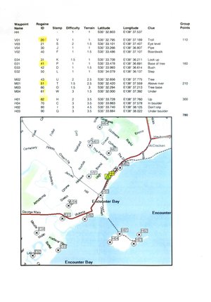
- Print out the master clue sheet. (Players do not get this.)
Map
- In Mapsource rename the caches according to the Geogaine ID and label the Hash House HH.
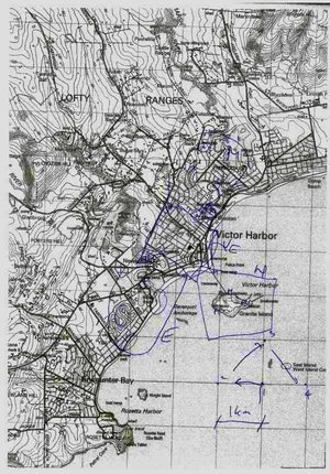
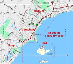
- Take a screen grab from Mapsource or whatever program you are using. Make sure it covers the entire area of the Geogaine. This will be the master map to help with allocating hiding and recovering the caches. The players never see this map.
- Remove all but the HH and 4 initial locations from the waypoint list in Mapsource and take another screen grab.
- Paste the screen grab into your favourite editing program and crop it to size.
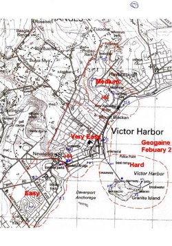
- Add 4 boundary lines to the nearest minute, the 4 zones for each difficulty as an area surrounded by a red dashed line with a label, a title and a scale. (See the example from the 1st Geogaine). Geogaine_Master_Map.jpg
Containers
- Prepare 18 (2 spare) 125ml clip lock style containers by painting them black. (These could be camouflaged to suit hide location if you have the time.)
- Remember to attach fishing line with swivels if you need to attach cache up high or don’t want to risk it falling.
- If caches are going underwater you will need better containers and secondary sealing.
- Put the unique stamp in each container and write this number on the lid in paint.
- Ensure you have 2 spare, ready to go containers with unique stamps. These are for replacements on the day if the caches go missing before or during the game.
Initial container clue sheets
- In the initial location container for each region is a buddle of slips of paper with the information to find the other caches in that region. Each team takes one piece of paper when they find this initial container.
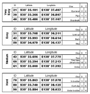
- The slips need to be large enough to read easily and should include the Geogaine ID, D,T, Latitude, Longitude and clue. (see examples)
- When the number of teams entering is known print out using a laser or other waterproof printer the number of teams plus 20% extra slips as backup.
Setting up
- On the morning of the day work out an optimum route around all 16 Geogaine locations and place the containers.
- Check each container as they are placed that they contain the correct stamp according to the master clue sheet.
- Make sure than the 4 initial locations in each location have their bundle of clue sheets within.
- On a copy of the master clue sheet mark off each location as it is placed.
What the Players get
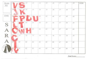
- A blank control card
- Before the event print off enough player sheets for each person, not just one per team.
- On the front of the A4 sheet should be the map showing the Hash House and the initial 4 locations as prepared in the section on maps.
- On the back of the sheet should be the clue sheet, as prepared above.
Scoring
- When players return to the Hash House their control cards are handed in and the time they returned is written on it.
- A master control card has all the stamps on it to enable quick checking.
- Scoring is done as per a Rogaine so for each Geogaine location found and stamped the points awarded are equal to the Geogaine ID number rounded down to the nearest 10.
- Teams are penalised by 10 points for each minute they are late.
- To determine winners the final points are ranked from most to least points.
- Ties are determined by the team who returns first.
Final stuff
- Presentation is made whilst everyone is still there and is normally a reverse count from least to most points.
- Organise people to go out and collect the Geogaine containers.
